Figure 1: Location of Merv
Digital Mapping and Remote Sensing at Merv (Digital Data Integration in a Field Context)
G. Barratt, S. Bullas, S. Doyle
Abstract - The paper falls into four main sections; section 1 is a brief introduction to the geographical and historic context of the Merv cities, the historical context content is based on work published by Georgina Herrmann, director of the International Merv Project. Section 2 gives an overview of the work carried out as part of the mapping programme in the period of 1992 to 1996. Section 3 describes field work carried out as part of the programme in 1996 and shows principally the use of digital survey and GIS technology to integrate ground based geophysical data with more distant aerial remote sensing in an attempt to approach a particular problem. Section 4 deals largely with the creation of a GIS system designed as a map integration and CRM tool for the area of the cities. The main text of the paper is written by Barratt with contributions in the areas of ground based geophysical remote sensing by Bullas and in the Merv GIS by Doyle. Any omissions and mistakes are attributed to the former.
< previous paper | section details | next paper >
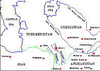
The ancient cities of Merv lie in the Murghab oasis on the edge of the Karakum desert in Turkmenistan centred at latitude 37 degrees 40 minutes North, longitude 62 degrees 10 minutes East (GPS navigation fix, Herrmann and Barratt 1995). Today a visitor to the site is faced with a landscape of desolation, punctuated by the occasional ruin of a mud brick building slowly dissolving into the surrounding dust. Yet this city was once a regional capital that flourished for more than two and a half thousand years, from the time of Alexander to its destruction in 1221 at the hands of the Mongols . At its height in the eleventh and twelfth centuries AD Merv was one of the most important cities of Islam, serving as the capital of the Great Seljuks, whose empire stretched from beyond the Oxus to the Mediterranean. The city occupied over 800 hectares and was described by contemporary travellers as one of the finest cities of its time (Herrmann 1996).
Archaeologically Merv is unusual in that the site is comprised of a series of cities built side by side rather than one on top of the other. Why this movement of settlement occurred is uncertain but the effect has been to create a stratigraphic record that is considerably more accessible than the more usual tell site. The earliest structure is the sub-circular enclosure of Erk Kala, which is believed to have its origins in the Achaemenian period dating from the sixth century BC (Herrmann and Barratt 1995). The walls of this first fortification survive standing to a height of over 30 m with a now completely silted outer moat enclosing an area of some 20 hectares. The second city of Gyaur Kala was constructed some time later on a rectangular plan, enclosing all but the northern quarter of the earlier Erk-Kala. This city flourished throughout the Parthian and Sasanian periods spanning from the second century BC to the seventh century AD (Herrmann 1996). Its principal remains comprise a massive perimeter wall of mud brick enclosing an area of some 327 hectares. Although today the wall is eroded and slumped, it still survives as a formidable barrier over 50m wide at base and standing over 20m above the surrounding plain. When intact the wall would have stood still higher, surmounted by a series of guard towers, the traces of which can still be identified. The internal plan of the city appears to be laid out in a north south to east west cruciform, following the line of two main roads which separate the city into roughly four quarters.
Gyaur-Kala and Erk-Kala were replaced with the more irregular plan of Sultan-Kala, the capital of the Seljuks. This seems to have grown originally as an unwalled suburb immediately west of the earlier cities sometime in the eighth century AD. The first defences being constructed sometime in the eleventh century under the rule of the Sultan Malikshah, enclosing a roughly square area of some 359 hectares (Herrmann 1996). The city rapidly outgrew the walls, and suburbs developed to the north and south. Further walling was built during the reign of Sultan Sanjar, enclosing these areas to give a total area of some 566 hectares, the largest size the city reached, the walls defended by more than 200 semi-circular towers. Sultan Sanjar may have also been responsible for the original construction of Shariyar Ark, the citadel of the city. This enclosure has been created by the construction of a wall across the north-east corner of the central, earlier part of the city walls, to form a roughly triangular enclosure with an internal area of 19.4 hectares.
The fall of the city came with the invasion of the Mongols in 1221 who were said to have destroyed the irrigation system that supported the city by breaching the supply dams. Following the Mongol destruction there seems to have been a collapse of population and a much smaller walled city, Abdullah Khan Kala, some 39.3 hectares in area, was built two kilometres to the south under the rule of the Timurid Shah Rukh in 1409 AD (Herrmann 1996).
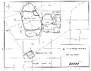
Figure 2: Overview plan of cities derived from
geocoded SPOT image
For the last 5 years Merv has been the subject of a multidisciplinary archaeological expedition, the ‘International Merv Project’, however only the Remote Sensing and survey programme will be considered here.
A fundamental aim of the expedition has been to create a digital map base recording the extent and form of the monuments. The intention being to use this as the base for a GIS structured SMR (Sites and Monuments Record) for the Merv Archaeological Park.
As initially no map information was available to the project a programme of blank sheet survey was undertaken. Logistic problems and the limited time available in the field made it impossible to accomplish the desired level of mapping by the more traditional ground survey techniques. These problems were seen as a positive opportunity to explore the advantages offered by the range of digital technologies which were increasingly becoming available to the field archaeologist. The technologies in question were Remote Sensing, Digital Survey, Global Positioning (GPS) and Geographical Information Systems (GIS). The vision being to fuse these technologies within a single methodology towards the recording of the cities of Merv. However in 1992 one basic problem existed, the only equipment available to the project was an ancient Sterling theodolite and a single Macintosh computer. It is therefore entirely due to the generosity of a few companies within the survey and software world (principally Leica UK) and the foresight of a handful of individuals within those companies that the mapping at Merv was able to take place at all.
It was clear from the outset of the project that it would not be possible to record the sites solely by ground survey. A considerable part of the mapping programme has therefore drawn on the use of remote sensing. This has comprised satellite data, (predominantly in the form of SPOT XS) and aerial photography from soviet archives and from original flying by the IMP (International Merv Project).
The aerial photographs were examined for their surface archaeological content stereoscopically using an optical stereoscope. Photographs selected for digital processing were converted to a digital format by scanning, using an A3 flatbed scanner. Experimentation showed that a suitable compromise could be achieved between image quality and file size by scanning at 300 dpi, giving tagged image file format (TIFF) files of around 17 MB. This was adopted as the base archive level and all such photographs were copied to CD (recordable compact disk) for secure storage. Selected areas of specific interest were scanned at the maximum resolution of 600 dpi and similarly archived. The images were then resampled at 150 dpi, creating smaller files averaging 3.5 MB. This was of particular importance when assembling rectified mosaics of the photographs as the smaller file size allowed more rapid image manipulation. The SPOT XS image originally obtained as a tape data source was also transferred to the medium of CD as a secure archive readily accessible to the PC computer (Barratt 1996).
The helicopter based photography taken by the IMP was of limited use for mapping purposes, its main value being as a reconnaissance set. However in particular instances sub-surface archaeological features appeared as surface marks as a result of flying following light rain (Barratt 1993). These oblique low level images, normally sub-standard for mapping purposes, have been warped to ground control points to facilitate plotting of the archaeological information in limited areas of investigation.
The intention of using diverse sets of remote sensing data made it necessary from the outset to create a co-ordinated framework of control points which could be used both as control stations for ground survey and as GCPs (Ground Control Points) for image rectification. In the first season, 1993, a ring traverse was established around the cities of Erk Kala and Gyaur Kala. This was accomplished using a Wild Total Station linked to a Huskey based ‘Autograd’ logging system. The control stations were chosen in advance of the helicopter flights and were ground marked for air visibility using building lime carried to the site in large sample bags. At this time no fuel existed for the teams vehicles, so everything was carried to the site on foot, a round trip of ten km (Barratt 1993). The ground marks however proved of limited use to the helicopter flights, as its ceiling didn’t allow more than two marks to appear on any one photograph. However the chalk survives mixing with the surface soil and still allows the familiar eye to identify the locations of the initial season’s control stations.
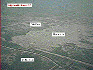
Figure 3: AP showing maximum ceiling achieved by
helicopter
Although the ring traverse proved successful in providing a spatial reference system within Gyaur-Kala, this was correct only within itself. No Soviet co-ordinate information was available relating to the Soviet triangulation points which existed in the vicinity of the cities and it was therefore not possible to tie control points into the Soviet Unified Grid Reference System which formed the basis of former soviet mapping1. This became of increased significance when back in the UK a SPOT XS scene and Landsat image relating to the area became available. There was a clear need for a means of tying the existing control stations into a wider framework and also adding a series of additional GCPs. At this time several survey equipment companies were developing more useable GPS systems. Among these was the Leica system 200, which from its specification appeared to offer the potential to provide the answer at Merv. A short training course at Leica confirmed the potential of the equipment. A collaboration between IMP, Leica and NE London University allowed a short period of access to a set of equipment which was a employed for ten days in 1993. This equipment was used to create a more extensive control framework of GCPs, points being selected on the ground for their common visibility on APs and on the SPOT image. The existing ring traverse control points and the ‘local’ Soviet trigs were included within this framework. This gave a comprehensive set of control points to WGS84 (World Geodetic System, 1984) covering the area of Gyaur-Kala and Sultan-Kala, an area of some five by three km.
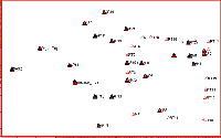
Figure 4: Plot of control framework
Satellite and AP data was subsequently georectified to these points and ground detail digitised on screen using Intergraph software to provide an overview plan of the cities (see Fig. 2), & (Herrmann and Barratt 1995).
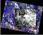
Figure 5: SPOT/AP mosaic of study area
By using the combination of ground survey, allied to satellite and aerial images, it has proved possible to optimise the time spent in the field and to continue the remote sensing work while in the UK. However where detailed surveys of specific areas of investigation have been required, providing spatial referencing for a variety of archaeological techniques, it has still been necessary to carry out considerable ground survey. This has been accomplished using GPS and a range of Total Stations and logging systems loaned to the project. One such task undertaken early in the project was the ground recording of the earliest part of the cities, the citadel of Erk-Kala. This massive sub-circular enclosure, the walls of which remain standing in excess of 30m high, was surveyed in 1993. Over 3000 detail points were recorded in order to record the monument in three dimensions and in digital form. A three man team, comprising two prism men and one observer linked by radio communication, worked on the site over a period of three weeks (Barratt 1993). The steep nature of the walls and loose surface made this task particularly arduous, as did temperatures in the 40s and at times high wind and dust storms. The dust conditions were such that one Total Station was rendered inoperable and work was allowed to continue only by the arrival of a replacement unit2.
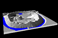
Figure 6: Total Station ground survey of Erk Kala
modelled in Visual explorer
A second, longer season of GPS based survey, using the next generation of Leica equipment (System 300) loaned by the survey department at UCL, was undertaken in 1995. With four weeks available it was possible to more fully explore the potential of the equipment. Additional control stations were added to those which already existed and some experimentation was carried out using the equipment in its kinematic role. In this mode the GPS records X, Y, Z data points at set time intervals, the shorter the set period the greater the resolution (and size) of the final data set. This technique was used both mounted on a vehicle and on foot. In the former case the antenna was mounted on the team Lada Niva and the road vehicle was driven slowly around the road network surrounding the sites. Downloaded at base, Leica SKI software was used to map this network.
Figure 7: GPS antenna vehicle mounted with inset
showing field plot of surveyed road network.
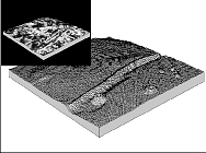
Encouraged by the success of this experiment a sling was rigged to allow the equipment to be used on foot. This method was used to record several archaeological surfaces, creating digital elevation models (DEMs) of these areas of terrain. Figure 6 shows an AP sub-scene of a section of the main east to west hollow way crossing through Gyaur-Kala, draped over DEM data supplied by kinematic GPS3.
The 1996 season of fieldwork supported by Leica and ER Mapper, was designed to build on previous seasons of survey, taking as its basic control GCPs fixed in the 1993 and 1995 seasons. The main centre of investigation was the Islamic citadel of Shariyar Ark described below.
The following is a brief overview of the site based on the 1996 survey and AP inspection. The citadel of Shariyar Ark lies against the north-eastern corner of the central, earlier, city wall of Sultan Kala. The internal area of the enclosure is some 19.4 hectares contained within a perimeter wall 1877m long. The north-western, northern and western sides of the enclosure are comprised of a series of straight sections of walling. These defences appear to roughly mirror the plan of the north-western corner of the earlier phase of Sultan Kala. It seems likely therefore that these portions of wall lie on the original line of the city wall. The more regular appearance and better state of preservation of the Shariyar Ark wall, compared to the western Sultan Kala walls, suggests that these sections were refurbished, probably at the same time that the secondary, western side of the enclosure was constructed. This section of the perimeter curves around the south and west sides annexing the interior of the Ark from the remains of the city to the south and west. The whole circuit of the citadel walls is surrounded by an outer dry moat averaging 20m wide and up to 3m deep around the south west and north sides. Around the eastern side the aerial photographs show the moat broadening into a series of interlocking ponds. Although now dry it seems probable that the moat was originally water filled for at least part of the year. The extant archaeological features visible above ground show that the interior of the site was laid out in a grid plan comprising a series of rectangular enclosures with associated courtyard buildings, associated subsidiary smaller buildings and a main NNE to SSW roadway. This appears on the 1977 aerial photographs as a well defined linear feature averaging 9m wide. It appears to be aligned at its northern end on a low flattened area. This area has dimensions of some 60m north to south by 55m transversely and is raised approximately 1m above the surrounding ground surface; local tradition attributes this area as the site of an open air mosque.
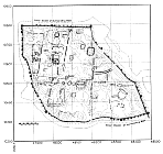
Figure 9: Plot of the 1996 survey of Shariyar Ark,
combined ground survey with AP transcription
Visual inspection and digital examination of a series of aerial photographs covering the area of ‘The Ark’ had been carried out prior to the 1996 field season. Two sets of photographs were used, one low level series believed to date from 1977, the second taken from a higher altitude believed to date from 1994. Visual inspection and comparison of the two sets show a considerable disparity in the amount of detail visible in the interior, even if allowances are made for quality with regard to the differing altitudes of the photographic sets. Although a rectangular grid layout of the buildings is recognisable in both sets, the 1977 photographs show what appear to be standing walls over the majority of the site interior. The later photographs show a much more denuded site. Stereoscopic examination using a simple Casella stereoscope confirmed this initial inspection. Unfortunately only the south-eastern corner of the site is covered by a stereo pair in the 1977 photographs, limiting stereoscopic work to this area only. Digital enhancement (using both Intergraph and ER Mapper imaging software) was carried out and a plot of the interior produced from the 1977 photographs.
The ER Mapper software suite was chosen in order that an image processing capability could be taken into the field. ERM offers a comprehensive range of image manipulation, filters and geo-processing tools and is designed for the PC. Particularly relevant to the Merv use, in which a Pentium 120 notebook with CD drive was used in the field, is the ERM system of storing the algorithm of the image manipulation used rather than the processed image, so avoiding the need for large data storage. In this way the base data could be accessed from the archive CD worked on and stored with little loss of valuable computer disk space. This was used in combination with the GIS system MapInfo via a beta version of the ERM dynamic link achieving rapid georeferencing of data sets.
The work on these photographs indicated that the state of the monuments’ preservation was good up until 1977 but that they had suffered accelerated deterioration between that date and the present.
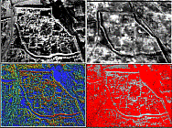
A principal aim of the 1996 survey work was to carry out a preliminary field investigation of this phenomenon and if possible quantify the rate of deterioration. The interior of Shariyar Ark was accordingly surveyed in three dimensions to facilitate the creation of a DEM. The position of standing monuments was recorded and the 1977 photographs were compared on the ground with the surviving monuments. Alongside the surface survey work a limited amount of geophysical work was carried out, designed to investigate key areas where archaeological features appeared visible on the 1977 APs but were no longer apparent on the later photographic set or on the ground.
A supervised single class classification of the 1977 AP in the so-called mosque area was carried out to identify pixels within the image which had similar spectral signatures to those obtained from a training area containing known archaeological features (for an account of supervised image classification see Lillesand and Kiefer 1994: 587-9). The scattergram facility available in ERM was used to rapidly achieve a correlation between the reflective response in the known area and the unknown area. The results indicated the presence of structures close to the present surface. A sample magnetometer survey of part of this area was carried out and is outlined below (see Fig. 11, & Bullas this volume).
Due to a general shortage of time, this area within Shariyar Ark was subjected to only a short systematic magnetometer survey (20m x 20m grid with 0.5m station and traverse intervals). The purpose was to verify the existence of walls which had been identified in the earlier aerial photography. The resulting plot is inset in Figure 11, the plot apparently showing the foundations of walling as anticipated. The results of the survey fitted well with the theories and conclusions of previous ground surveys and with the existing remote sensing data as far as the mud brick foundations of these substantial walls and buildings were concerned (Bullas this volume) or (Strange 1994). For a more detailed account of the 1996 geophysical programme at Merv see Bullas (this volume).
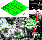
Figure 11: location of magnetometer sample grid and
resulting plot
Throughout the survey work carried out at Merv an attempt has been made to both record the site and to examine developments in survey technology in a field context, a philosophy continued in 1996. To facilitate data capture, the IMP were loaned a set of Leica Vector DAES 1000 Laser Binoculars, a former military ranging tool, which employs a laser and in-built digital compass to calculate the distance and azimuth bearing from the instrument to a ground ‘target’ object. To some extent this allows the user to remove the need for a traditional prism/target man. Data was logged using PenMap logging software connected to the survey instrument. The connectivity between software and hardware proved useful and greatly assisted the field programme as data capture and surface modelling could be monitored in ‘real-time’ on the ground. Whilst the accuracy of the binoculars was lower than that of the Total Station, this was largely offset by the speed at which a ‘coarse’ level of detail could be recorded. Furthermore the export facility from the digital field equipment meant that data could be transferred into the existing GIS database in less than an hour from the time of data capture (including travel time). This laser ranging system is comparatively new to the surveyor’s tool kit. It is not regarded as a precise survey tool, being limited to +/- 1m. However the equipment does provide a highly portable and rapid means of collecting a large volume of three dimensional survey data. Linked with a visual logging system such as PenMap it is an excellent mapping (as opposed to survey) tool, its relationship to the more accurate EDM/Total Station being comparable to that of the plane table vs. the theodolite. Used in the role outlined above, it allowed a large volume of measured data to be collected within a time frame similar to that required for a reconnaissance sketch survey.
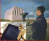
Figure 12: Leica Vector ranging binoculars with
PenMap
The use of such rapid (potentially one man) digital ground survey as a means of spatially relating data, here combining remote sensing digital images with ground based geophysical remote sensing and detail survey, allowed rapid common georeferencing of diverse separate data sets (while in the field). A considerable advantage of this facility was the removal of any possible confusion which can occur when such variable data sets are combined at a distance from the field monument.
Comparison of the air photographs taken in 1977 with the extant surface archaeological features show the extent to which the site has been subjected to erosion over the last quarter of a century. Measurements of parallax difference obtained from the rather limited stereo photographic cover, using a mirror stereoscope and parallax bar, indicate a surface erosion of between 1 and 2 m in the period 1977 to present (for a concise description of parallax measurement see Ritchie et al 1988). It seems clear that some major influence has affected the monument in this period. Although it is hypothesis only, it seems likely that this accelerated degradation is a result of changes in the water table resulting from the construction of the Karakum canal. The full mechanism is not as yet understood and remains to be more fully explored. However the survival characteristics and therefore the management requirements of the site are a considerable cause for concern.
One aim of the International Merv Project from its conception has been to create a digital record of the sites, capable of being managed within a Geographical Information System. In 1992 this aim was somewhat ambitious, given the lack of resources available to the project. GIS technology was initially chosen in order to integrate and consolidate the mapping programme. If the promise offered by GIS proved real in a field application then it would not only allow the mapping teams the ability to manipulate the spatially referenced data with relative ease, it would also provide the mechanism for the broader IMP to integrate spatial data and their attributes relating to, for instance, finds scatters, magnetometer or resistivity survey, elevation models and so on, in one digital space. By embarking on such a path, it was reasoned that it would become relatively easy to progress towards a prototype Cultural Resource Management (CRM) tool using GIS as a useful hub. Such a system obviously has many parallels with the Sites and Monuments Records (SMR) systems in operation in the UK.
Although there have been problems, due largely to the difficulties of getting diverse data sets and individuals into a common spatial ground, it has been possible to achieve at least part of the aims. Initially Intergraph MGE software has been used as the main GIS engine for all mapping work. However the difficulties involved in porting such a power GIS into the field led to the exploration of other packages more suitable for use in a more CRM oriented role in the field.
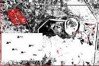
Figure 13: Screen shot of data integration in
Intergraph MGE, GIS.
The first stage in creating the GIS was to integrate the base mapping and GPS work which laid the foundation for the mapping program. Whilst many GIS were available MapInfo was employed as it was desktop / Windows based and work in the Northamptonshire SMR headed by Glenn Foard indicated that MapInfo was a package which could fulfil this role (UNIX was not an option as the system would have to be laptop mounted for fieldwork). MapInfo was also readily customisable, plus it would export data to shape file and DXF format necessary if the CRM had to migrate to a more powerful GIS (i.e. ArcInfo) at a later date. Furthermore the system would allow the integration of 1:10,000 Soviet maps using their original datum and spheroid (WGS84). Having transformed the temporary site grid to the Soviet geo-referencing system the IMP study area became identifiable in real space. The power of the GIS to integrate the data became evident from an early stage although there were difficulties in trying to shoe-horn the data into a data structure which had to be designed after the event. For anyone anticipating GIS playing a part in any given fieldwork it is far more economical to spend time at the beginning of the project considering data structure than it is to spend weeks swimming against the stream, transforming and converting data. Nonetheless MapInfo served well enough and proved robust enough to begin adding attribute data to the base geometry data.
In order to bring the CRM GIS to the fore and to utilise its functionality, a pilot study was undertaken on the MGK5 site which is located within the north eastern corner of the walled city of Gyaur Kala. Within this pilot study 1:20 and 1:100 field plans were digitised, the finds record was converted to a digital format (using a highly portable, hierarchical data structure) within a relational database, and trench locations and physical structures were converted into the CRM’s now established co-ordinate system. Again, time could have been saved if the field workers had been digital in terms of their data capture, or if the excavators had considered the spatial nature of their data. Obviously considerations of the cost of data loggers and the harshness of the environment have to be held in mind. Nonetheless, the pilot study proved to be successful in that all the available data had been incorporated and attributes had been attached to the various spatial elements in the pilot area.
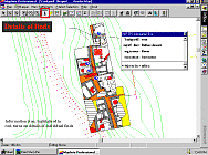
Figure 14: Screen shot from MapInfo IMPGIS showing
data interrogation
The next stage of the process was to allow data to be disseminated from the CRM GIS. This process took two forms; firstly data could simply be printed out to hard copy and secondly data could be accessed by the non-specialist via a customised GIS interface4. The customised system retained enough functionality for the inexperienced user whilst not being overly intimidating or complex, or of too little use. The system was thoroughly tested in the UK over a six month period prior to the 1996 season, wherein it served robustly in the field as an extremely useful tool in the mapping and integration of newly acquired data. By having a working, digital SMR in Turkmenistan as an integral part of the field survey, processed data was captured and integrated at a rapid rate without the need to haul kit and information back to the UK. Decisions could be made in real time in the field which ordinarily could not have been made. In short the use of GIS in this instance allowed the following to be facilitated; consolidation and integration of pre-existing fieldwork with data from AP, remote sensing and ground survey together with, in a limited area, geophysical and excavation data. The data structuring within an allied relational database (MS Access) has been used to create a pilot Cultural Resource Management Tool or pseudo-SMR. Finally installed on a 120P laptop computer it has also created an interactive information dissemination and demonstration tool, allowing the user to navigate in 2D space and interrogate the data by means of a suite of customised icons. While the IMPGIS is considered a prototype application only, it functions reasonably well, allowing the user to drop in from a satellite image, through zoom levels to an excavation trench and single find.
The International Merv Project has been ambitious in its use of digital technology in a physically demanding environment, conditions which have tested technique and equipment at times to the point of destruction. The equipment and software used has been well beyond what an impoverished archaeological research project could realistically afford to either purchase or hire in a commercial world. It is only through the generosity and foresight of companies like Leica, Steanne, Intergraph, ER Mapper and, for a period, the Ordnance Survey that the mapping project at Merv, a comparatively small part of the overall International Merv Project, has been able to function at all. It is clear from the results obtained in these difficult circumstances that the technology used in the project has a proven and important role to play in similar future research projects and in the broader world of cultural resource investigation, conservation and management. Indeed as high resolution remote sensing data become more readily available, potentially to sub 2m resolution, the possibilities for its use within the discipline can only expand. So too as digital technologies grow closer together the boundaries between remote sensing, GIS and survey will erode creating a single suite of software perhaps as familiar as MS Office is today. However despite the promise within the technology the question has to be posed, where will the necessary funding be found to provide not only the equipment, but the data, in a world were IT and digital data have a growing commercial role? Archaeological field research cannot rely indefinitely on the generosity of firms to loan equipment or give free data. Perhaps more importantly, where too will the future field archaeologist be trained in familiarity with the necessary digital technology, when few university archaeological departments have physical access to the technology that the student of archaeology will need to be familiar with in the next millennium?
The survey programme at Merv has functioned only as a result of the support of companies and individuals willing to donate equipment, time and enthusiasm. Particular thanks are due to the following. For funding: National Geographic Society, British Academy, Stein Arnold Fund and Kung-Peh Shen Foundation, CINECA. (Thanks also are due to Georgina Herrmann for her tireless efforts in obtaining funding). For equipment and software: Steanne Solutions, Leica UK, Intergraph, ER Mapper, University of East London, Department of Photogrammetry and Survey UCL, Ordnance Survey. Particular thanks are due to the following individuals: Chris Barratt Phillips, Dave Mackie, Peter Boyer, Eddy Moth, Ian Peet, Sally Campbell and Simon Doyle all gave 100% support as members of the various survey teams 1992 to 1996. Steve Turner (Steanne Solutions) and his team, Mark Concannon and Simon Meres (Leica UK) who have given continued support throughout the whole project, Dominic Cuthbert (ER Mapper) for his advice in remote sensing, similarly Derrold Holcomb of ERDAS who ventured into the field briefly in 1995, Chris Gill for his help and advice solving CAD problems, and last but by no means least the best systems support guy I know: Mike Longmore.
1 Soviet Mapping was originally carried out by the Glavnoe Upravlenie I Kartografi. Projection was Gauss-Krueger, UTM zone 41, with all survey based on a unified system of geodetic control with a standard sheet division and numbering system.
2 In over 20 years working with electronic survey instruments I have never experienced the problems encountered at Merv. This is true for not only survey equipment but for any optical or electronic equipment which when subjected to the heat and dust of Merv have invariably developed faults.
3 The vertical z values are here doubled to accentuate the topography.
4 The MapBasic programming necessary was written by Simon Doyle, currently of CASA (Centre for Advanced Spatial Analysis) UCL.
Herrmann, G, 1996 Merv, ‘Queen of The World’, Minerva, Vol. 7, No. 6, 15-22
Strange, P, 1994 Results of the 1993 geophysical survey at Merv, Pers. comm.